We scanned Pikes Peak ourselves. Two expeditions to Colorado. 650 GB of data. 20,000 metres of road placed by hand. And we can’t let you drive it.
It started with an email.
May 2024. We wrote to the CEO of Pikes Peak International Hill Climb asking if we could buy their 3D scan data of the course. We explained what we needed it for. We asked whether anyone else had it.
Two sentences back. They don’t release scans to third parties. Protected IP.
We kept writing. Found out the road is a public toll highway on US Forest Service land. Found out their exclusivity agreements with gaming sponsors meant they couldn’t help us even if they wanted to. Found out that if we wanted to scan it ourselves, nobody could stop us — we just needed the right permits.
We also looked at whether a public release might still be possible. The Pikes Peak Highway is public land, which arguably puts the road layout in the public domain. Rename it. Remove trademarked signage. Call it “Colorado Hillclimb.” It might work, we were told.
It didn’t matter. When Pikes Peak – America’s Mountain responded directly, the message was clear. They would not want it released in any form. The leak risk alone would cause problems for the race organisation. The door closed.
So we got the permits. We scanned it. We built it. And we kept it.
The first time I drove the finished track, the word that came to mind was: what have I done. A mountain in Colorado. Built into a computer. Driven from a room in Estonia. Ten years ago I would not have believed any part of that sentence.
Then the second feeling arrived — the one that hasn’t left.
We can’t let you drive it.
The Distance
We are based in Europe. Pikes Peak is in Colorado. 9,000 kilometres separate our workshop from the start line.
Every team that travels to Pikes Peak from outside North America faces a version of this. The ones with factory backing fly their drivers over repeatedly — walk the road, build familiarity over multiple visits. We do not have that option. We will develop the car on circuits in Estonia and Norway, ship it across an ocean, and arrive at the start line having never driven the actual road.
A simulator built on guesswork doesn’t fix this. If the mountain in the sim isn’t the actual mountain, the driver is learning the wrong thing. That is worse than not practising at all.
So we sent a team of experts to Colorado. Twice. And we built the mountain ourselves.
The road and the mountain. 19.99 kilometres. 156 corners. 1,440 metres of elevation gain.
What That Took
Pikes Peak is 19.99 kilometres of public road. 156 corners. 1,440 metres of elevation gain. To build it accurately enough to be useful, you have to measure it — not approximately, but exactly. That required professional survey equipment, two expeditions, and months of processing.
September 2024 — The Geometry
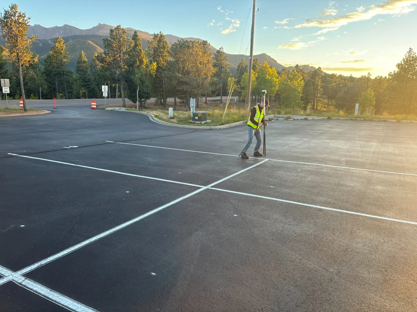
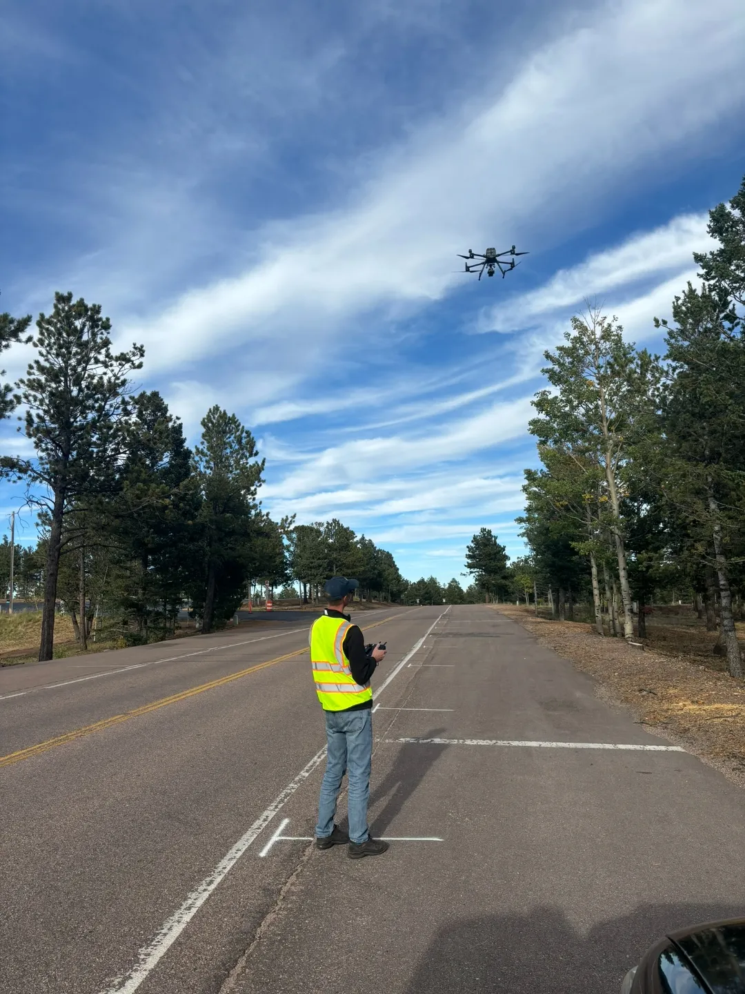
Sirkel & Mall, an Estonian geodesy company whose day job is construction surveys and land measurement, flew to Colorado and spent nine days on the mountain. Getting there was not simple. The highway runs through a national park. Permits had to be obtained. Safety briefings completed. Rules learned. The road stayed open to tourist traffic throughout. They worked around it.
The capture used four data layers, each more precise than the last.
IER Simulations sourced publicly available airplane LiDAR data — laser mapping from altitude — to establish the gross terrain at 10–30cm accuracy. Enough for geography. Not enough for a racing surface.
Sirkel & Mall placed GPS ground control points at precise locations along the road — physical reference markers that anchored every subsequent data layer to a single real-world coordinate system. Without them, the data floats.
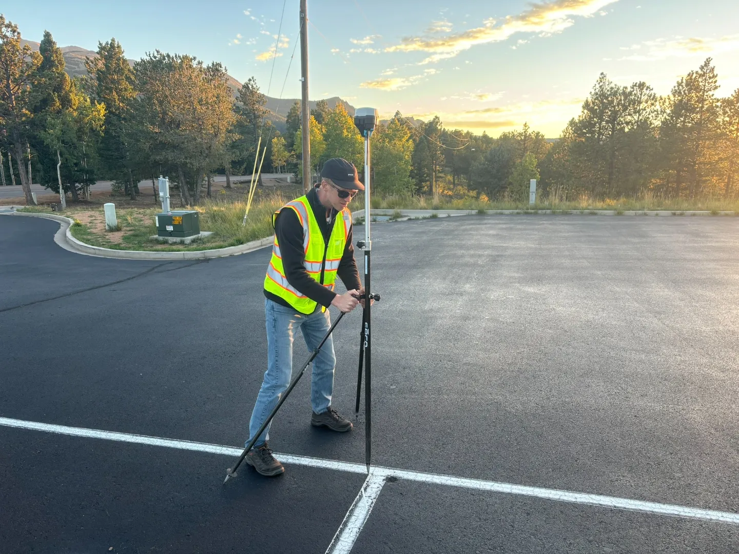
GPS rover calibration on the painted start line. Every data layer anchored to these reference points.
Drone photogrammetry mapped the road’s immediate surroundings at 1–3cm accuracy: the rock faces, drop-offs, verges — everything a driver reads at speed to understand where the road is going.
Vehicle-mounted LiDAR drove the tarmac itself. The RIEGL scanner on the survey vehicle’s roof fired millions of laser pulses at the road surface, capturing camber changes, surface transitions, every corner — at 5mm precision.
From 30cm to 5mm. Four layers. Nine days. 650 GB of raw data.
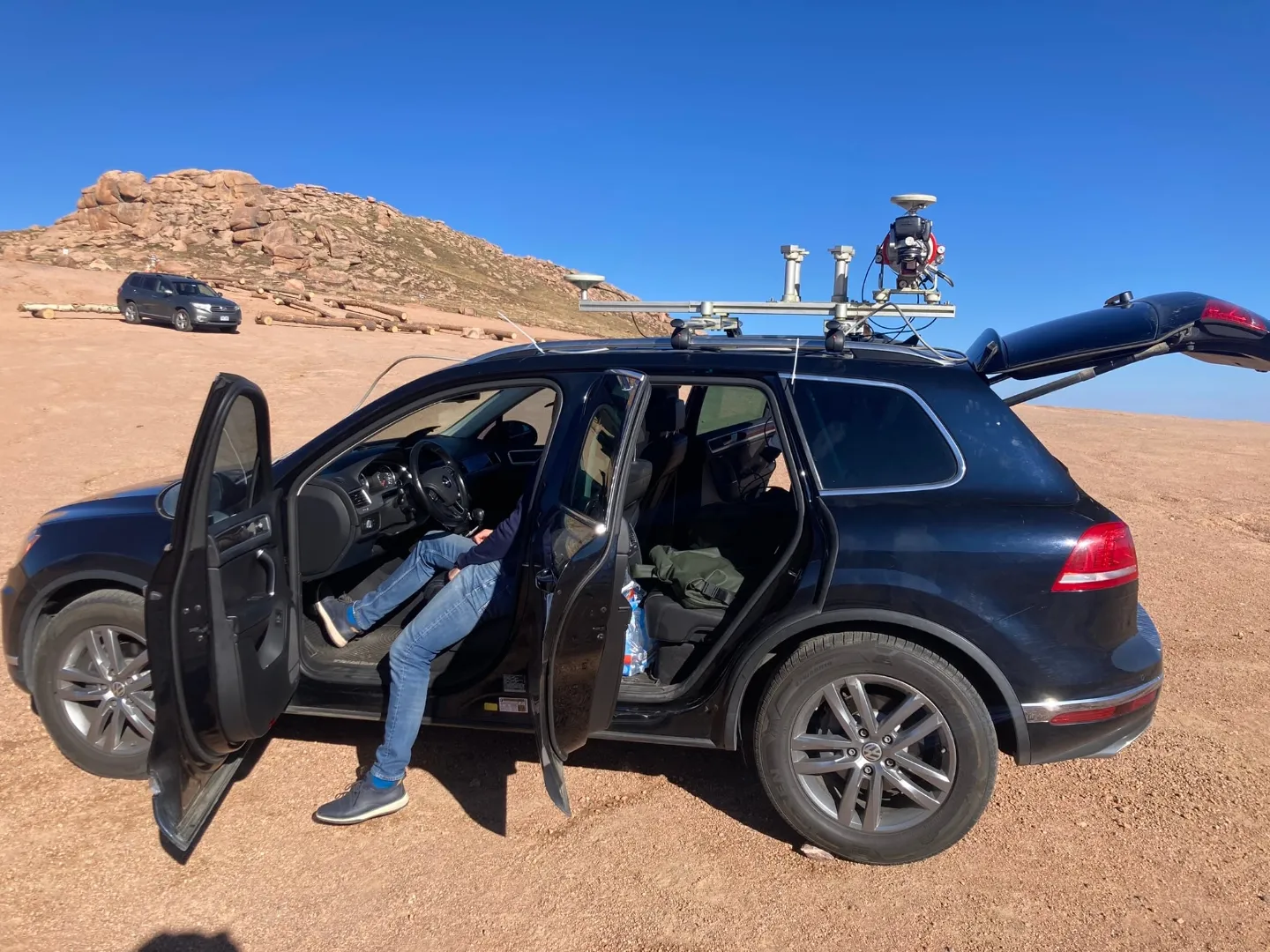
The LiDAR-equipped survey vehicle at the summit. Colorado plains 1,440 metres below.
August 2025 — The Surface
The geometry tells you the shape. It doesn’t tell you how the road feels.
FORS Performance — a specialist measurement company working with F1, Formula E, DTM, and WEC — came back to the mountain with a different instrument. Their Grip machine measures the microscopic character of the road surface: roughness, bumpiness, friction — all logged continuously against GPS, so every reading is tied to an exact position on the road. Lower grip at Hansen’s Corner. A significant drop at Heitman’s Hill. Bumpiness rising from Gaxyler’s Straits to Grouse Hill. Temperature falling from 35°C to 15°C through the shaded tree sections. Not estimates. Measurements.
Without this layer, you have a track that looks right. It still doesn’t behave right.
Drone photogrammetry capture. 1–3cm accuracy on the road surroundings — rock faces, drop-offs, verges.
Building the Mountain
Then IER Simulations spent several months building.
Every metre of road surface was placed by hand — 20,000 metres, individually, because automated methods couldn’t meet the required precision. Maximum positional error on the finished model: 5cm at the road edges. Vertical: essentially zero.
The surface texture data fed directly into the tyre model — informing how rubber behaves on this specific tarmac, its grip characteristics, its temperature sensitivity. The direct grip measurements were cross-checked against the Porsche Ring, a track with years of real-world validation data, to confirm the relative grip levels corner to corner were correct.
The simulation engine recalculates the car’s physics 2,000 times per second. Assetto Corsa — the simulator platform most people know — runs at 333Hz. iRacing runs at 360Hz. The difference is not cosmetic. At higher frequencies, physics systems become possible that simply cannot function at standard rates. The platform includes real-time suspension compliance and physical tyre carcass deflection — two systems that depend on each other. Without real-time suspension compliance, dynamic camber is wrong. Without correct dynamic camber, the tyre model produces incorrect results. Errors compound. The platform shares approximately 5% of its code with Assetto Corsa — its open source kinematic solver. The remaining 95% is IER’s own.
The result is a simulation where nothing is independent. Get one component wrong and the error cascades through everything else. That is a different category of tool from what is commercially available.
What It Feels Like
Pikes Peak is harder to learn than the Nordschleife — the German circuit that most people consider the most demanding track in the world. At the Nordschleife, corners have a logic. A rhythm builds.
Pikes Peak doesn’t work that way. In the beginning it was crash after crash. It took a while to even reach the summit. The problem isn’t learning which way the corners go — it’s learning where the bumps are. The traditional racing line often doesn’t apply, not because the geometry is wrong but because the bumps change everything. There are sections where you have to position the car at the very edge of the road simply to see a braking marker. On the inside, the marker disappears. And if you brake too late, there is no runoff. There is a cliff.
The bumpiness was the thing we were least prepared for. The data showed Pikes Peak running at roughly three times the bumpiness of a purpose-built race circuit. When we first drove the sim, we assumed something was wrong. The car was hopping under braking — the kind of behaviour that makes estimating braking distances almost impossible, and that only a very specific suspension setup can manage. We checked the data. We checked it again. It wasn’t wrong. The mountain really is that rough.
That discovery alone justified the project.
The sim also partially models altitude effects — how aero and engine behaviour changes as the air thins from 2,800m at the start to 4,300m at the summit. That correlation is still being refined. Every month it gets closer.
By the time our driver stands at the start line in Colorado, the bumps will already be familiar. The braking markers memorised. The suspension decisions being made right now — months before the event — are being shaped by surface data that no onboard video has ever captured.
That is what it is for.
Why You Can’t Drive It
The scan is legal. The track exists. It just can’t leave our hands.
It was built for one purpose. It will serve that purpose.
If you want to drive Pikes Peak, you’ll have to go to Colorado.